Projects:RegistrationLibrary:RegLib A01
From NAMIC Wiki
Home < Projects:RegistrationLibrary:RegLib A01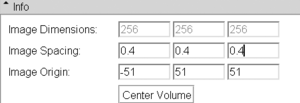
Back to Registration main page
Back to Registration Use-case Inventory
Registration Library : Using Grid Images
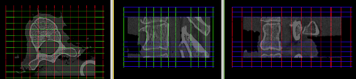
1.Match physical dimensions & position
- Load grid image with the desired number of grid points (e.g. ~50% higher than the DOF of the BSpline applied)
- Place your target image in background and grid image in foreground
- Go to Volumes module / Info tab
- select first target and then grid image from Active Volume menu; for both click on Center Volume button to match image centers
- set fading slider to halfway, so you can see both target and grid image
- select grid image from Active Volume menu
- change Image Spacing parameters (voxel size) to something close to those of your target image. You will see the grid change shape as you adjust. Make numbers smaller or larger to change the box sizes. Click the Center Volume button after each size adjustment. Continue until grid largely covers area of interest


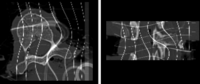
2.Deform
- go to ResampleScalarVectorDWIVolume module (Filtering menu)
- select grid image as input, your target as reference
- select "create new volume" from output volume and rename to "grid_deformed" or similar
- under Transform Node select the nonrigid (BSpline) transformation
- as interpolation method, select "nearest neighbor". If continuity of the deformed grid lines is important, select "linear"
- leave rest at defaults; click Apply.


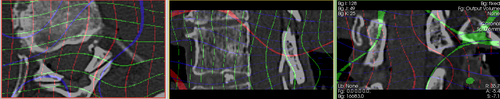
3.Evaluate
- the grid images have different values for the axial, sagittal and coronal planes to help you distinguish. An orthogonal plane being bent down into an adjacent slice shows up as rings or blobs. You can adjust the window & level values to match the particular plane and thus fade out the distracting other ones. Or you can threshold the grid image to generate labelmaps that contain only 1 set of planes for easier viewing.
- the alternative 4D grid image contain each plane as a separate channel and are loaded as vector images that will show up in color (see figure above) that help distinguish the different directions.