File:EMSegment-Phalanx-DistanceMap.jpg
From NAMIC Wiki

Size of this preview: 800 × 489 pixels. Other resolutions: 320 × 195 pixels | 861 × 526 pixels.
Original file (861 × 526 pixels, file size: 33 KB, MIME type: image/jpeg)
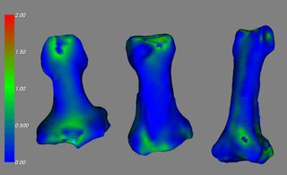
Validation of EM Segmentation - Distance Map with laser scanned surface
File history
Click on a date/time to view the file as it appeared at that time.
| Date/Time | Thumbnail | Dimensions | User | Comment | |
|---|---|---|---|---|---|
| current | 00:08, 7 January 2008 | | 861 × 526 (33 KB) | Vmagnotta (talk | contribs) | Validation of EM Segmentation - Distance Map with laser scanned surface |
- You cannot overwrite this file.
File usage
The following page uses this file: